
” data-check-event-based-preview data-network-id data-details data-freewheel-lede=”true”>
Warmer weather ahead for much of the US after arctic blast
00:59 – Source: CNN
CNN —
Commuters in large swathes of the central US will face freezing rain and ice on Monday – just as a blast of warm air begins to thaw much of the winter-weary eastern US.
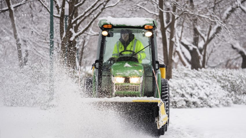
A barrage of back-to-back winter storms this month have left at least 82 people dead in 13 states as severe conditions have left people crushed under fallen trees, trapped in tornadoes or tangled in snowy car accidents.
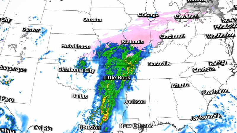
Now people from Dallas to Michigan could see accumulating ice and freezing rain through Monday. Weather officials and several local transportation departments have warned drivers to exercise caution – or stay off the roads entirely.
“Icy roads will make driving hazardous. Use extra caution and drive slowly!” the Weather Prediction Center said.
The majority of the regions facing an icy forecast are likely to receive less than a quarter of an inch of ice by Monday evening, but up to half an inch of ice could build up in northern Arkansas and southern Missouri, according to the National Weather Service.
Meanwhile, parts of eastern Texas and the Lower Mississippi Valley will be showered with rain and possible thunderstorms as a wave of warm air brings unseasonably warm temperatures to much of the eastern US.
Moisture from the Gulf of Mexico began pushing northward over the weekend and into Monday, colliding with the cold air still hovering over parts of the central US to create ice and freezing rain conditions over the Plains and Midwest.
More than 40 million people from northern Texas to the Great Lakes are under winter weather alerts Monday, prompting road hazard warnings in several states.
In Missouri, where winter weather advisories are in place across much of the state, the National Weather Service warned of slick, icy roads and sidewalks and possible power outages in some areas.
“Freezing rain is expected across most of the state overnight through Monday creating potentially icy conditions. Please avoid travel if possible or delay your trip,” the Missouri Department of Transportation said Sunday in a post on X.
Ice storm warnings are also in effect Monday for parts of northwest Arkansas and eastern Oklahoma.
Ice was already building up on bridges and overpasses in the area Sunday night, the weather service in Tulsa said in a forecast message. The forecasters warned drivers to use “extreme caution” if they have to travel and leave ample distance for stopping.
“Please slow down and use caution as rain may freeze to your vehicle while driving and roads that appear wet may actually be icy!” the Tulsa weather service said in a post.
In Memphis, Tennessee, cold temperatures caused water mains to break, leaving thousands with their service interrupted over the weekend, Memphis Light, Gas, and Water CEO Doug McGowen said Sunday. Most should have their service restored by Monday, and a boil water advisory could be lifted by Thursday, McGowen said.
Significantly above-average temperatures will spread across the east by the end of the week as a series of fronts and low-pressure systems usher in warmer air and tropical moisture.
After shivering through a frigid weekend, some cities will see daily high temperatures soar by nearly 30 degrees in the coming days.
Thursday’s highs are set to hit the upper 60s and 70s in the Southeast and the 50s as far north as New York. More than 140 records for warmest daily lows could be broken by Friday in parts of the Southeast, where overnight lows will soar into the 60s.
“Temperatures thaw out this week & will stay well above normal through the end of January,” the weather service office in the Twin Cities posted on X, later adding a future of near-record highs “certainly looks possible, stay tuned!”
Though the rush of warm air will shake off the arctic blast that dominated much of the country’s weather through the weekend, it could usher in hazardous rain and flooding.
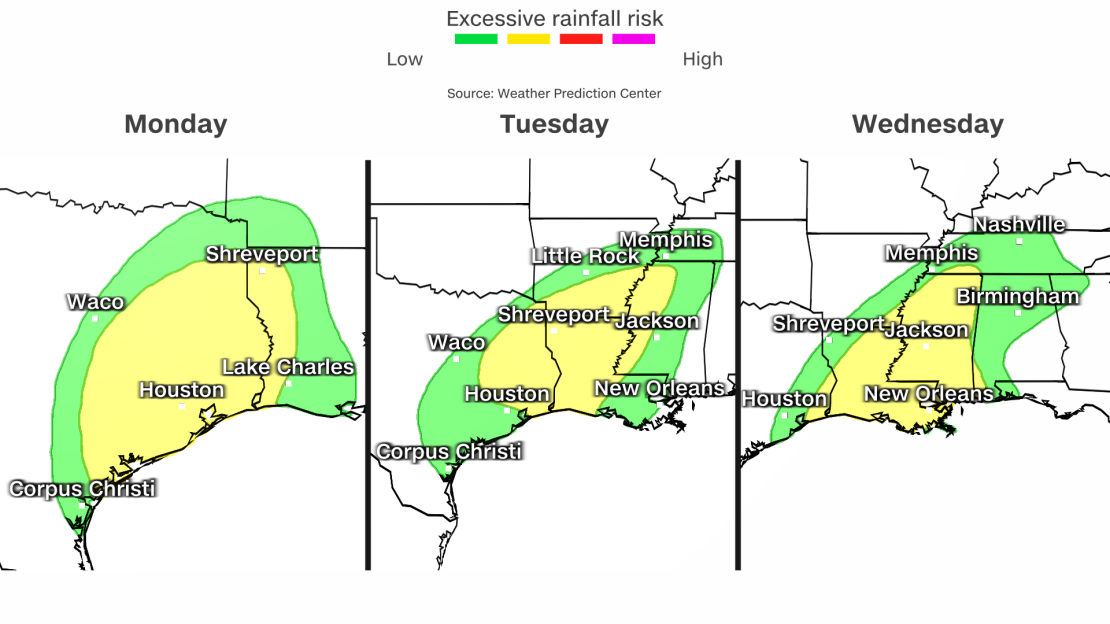
Heavy rain will bring a threat of flooding along the Gulf Coast and western portions of the Southeast until late in the week.
Approximately 37 million people across the impacted areas are under threat of flash flooding and excessive rainfall through Thursday morning. As many as 5 to 6 inches of rain could fall by the end of the week, with some areas seeing even more.
Here’s a glimpse of where the heaviest rainfall is expected across the South through throughout the week:
• Monday – eastern Texas, western Louisiana and southwestern Arkansas
• Tuesday – eastern Texas to southwestern Tennessee
• Wednesday – Texas-Louisiana border to central Tennessee
• Thursday to Friday morning – Gulf coast of Louisiana, Mississippi and Alabama to the far western corner of North Carolina
Some areas will be under a Level 2 of 4 risk of excessive rainfall for several days in a row.
CNN’s Sara Tonks and Joe Sutton contributed to this report.