
KANSAS CITY, Mo. – A severe weather threat is expected to continue across portions of the Midwest as a typical spring storm system tracks eastward on Tuesday. Very large hail, destructive wind gusts and a few tornadoes are likely.

(FOX Weather)
Tornado Watch issued for Des Moines as storms begin to fire
A Tornado Watch has been issued for parts of southern Iowa and western and northern Missouri until 6 p.m. CDT. A second Tornado Watch has been issued for eastern Iowa, western and northwest Illinois, northeast Missouri and southwest Wisconsin until 8 p.m. CDT.
A third Tornado Watch has been issued for western and northern Iowa, northeast Nebraska and southeast South Dakota until 7 p.m. CDT.
“When you’ve got a watch in place, it means that the ingredients are there for potentially a tornado to form, and potentially a Tornado Warning to be issued,” FOX Weather Meteorologist Craig Herrera said. “When a Tornado Warning is issued, it is time to get to your safe spot.”
APRIL KICKS OFF AMERICA’S MOST ACTIVE TIME OF YEAR FOR TORNADOES

(FOX Weather)
Early Tuesday morning, an American Airlines flight from Kansas City to Chicago returned to the airport due to a possible lightning strike. The flight landed safely at Kansas City International Airport and taxied to the gate under its own power. The airline told FOX Weather that a maintenance team is inspecting the aircraft, and all customers have been accommodated on alternate flights.
In Clay County, Missouri, there was also damage to trees near the Camp Branch area of Smithville Lake, according to National Weather Service storm reports. A mobile home was flipped over, but no injuries were reported.
The NWS office in Topeka, Kansas, said it received several reports of damage across Osage County, to the south of Topeka. A survey team is heading out Tuesday to determine the strength of the winds that caused the damage.
As the storms continued moving towards the east, an emergency manager reported a tornado in Platte County, Nebraska, 3 miles southwest of Platte Center. The manager also reported that the tornado roped out and touched down again.
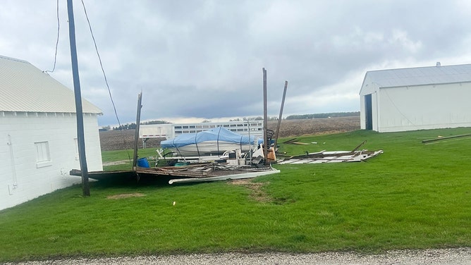
Another tornado was confirmed within a Tornado Warning just east of Minburn, Iowa, in Dallas County. Damage to an outbuilding and sheet metal scattered in fields, according to NWS storm reports.
-

Storm damage from Dallas Center, Iowa, on Tuesday morning, April 16, 2024. (Mike Howell)
-
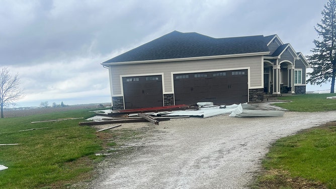
Storm damage from Dallas Center, Iowa, on Tuesday morning, April 16, 2024. (Mike Howell)
-
Storm damage from Dallas Center, Iowa, on Tuesday morning, April 16, 2024. (Mike Howell)
-
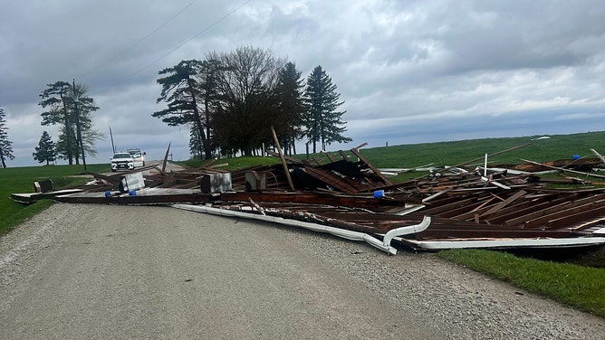
Storm damage from Dallas Center, Iowa, on Tuesday morning, April 16, 2024. (Mike Howell)
The FOX Forecast Center will be tracking storms from portions of the Midwest to the Ozarks of northern Arkansas, where severe weather is expected to continue Tuesday and into the overnight hours.
As an area of low pressure slides eastward, storms will break out behind a warm front in Iowa, Missouri and Illinois. This is where the severe weather ingredients will line up to produce the greatest chance of supercells capable of spawning tornadoes.
Iowa sees its first widespread severe weather threat for 2024
NOAA’s Storm Prediction Center (SPC) has issued a Level 3 out of 5 threat for severe weather for nearly 3 million people, which includes significant cities in Iowa such as Cedar Rapids, Des Moines, Davenport, Iowa City and Waterloo.
“This is where we have the highest risk to see tornadoes. This is what we call a hatched region … issued by the Storm Prediction Center,” FOX Weather Meteorologist Kendall Smith said. “This is where we have the potential to see strong violent tornadoes – EF-2 or stronger. We could also be talking about damaging winds, potentially 70 mph, that could down trees and down power lines as well. Large hail is actually our primary threat, and we have a large swath of real estate that could see 2-inch diameter-sized hailstones or larger.”

Scattered severe thunderstorms are likely for Tuesday, April 15, 2024, centered mainly over the Midwestern states of northern Missouri, Iowa and northwestern Illinois.
(FOX Weather)
According to Chad Hahn, a warning coordination meteorologist at the National Weather Service in Des Moines, Iowa, this is the state’s first potential for widespread severe weather this year.
“Looking back, historically, we had a fairly slow start to severe weather season this year,” Hahn told FOX Weather on Monday. “We’ve only issued one warning to date. You’d have to go back to 2003 for the last time that’s happened.”
The FOX Forecast Center said one of the biggest differences between Monday and Tuesday is that storm activity appears to have a better chance of lining up with the peak daytime heating. That, combined with decent low-level moisture and atmospheric instability, will allow storms to produce significant hail and a few tornadoes.
The biggest uncertainty will be the ongoing morning storm activity Tuesday morning. If the rain in the early part of the day disrupts the daytime heating, then it will reduce the severe weather ingredients. If we get a clearing period and allow the atmosphere to rebound, then it could be an extremely active day for some of the central states.
Farther south toward the Ozarks of northern Arkansas, storms will break out along a cold front and potentially out ahead of it as more discrete cells. Low-level moisture will be much higher in this area, and wind shear – the change in wind speed and/or direction with height – will be in place to help promote rotating storms.
All severe storm threats are possible, but we could be looking at a more defined corridor for tornadoes, the FOX Forecast Center said.

A look at the severe threats and locations for Tuesday, April 15, 2024.
(FOX Weather)
Parts of the South could see an increase in their severe storm threat level as details become clearer.
The coverage across this region will likely not be as great as the northern extent, but these storms could pack a punch for locations that had a very busy past week.
Wednesday’s severe threat shifts east
Day three of severe storms will see the action shift to the southern Great Lakes and the Ohio Valley.
Scattered thunderstorms are possible across parts of Michigan, Indiana, Ohio, Kentucky and Tennessee. The SPC issued a Level 2 out of 5 risk for portions of Indiana, Ohio and southern Michigan.
The timing for storms begins Wednesday afternoon and will continue into the evening hours. The highlighted area may experience a mix of severe hazards, including hail, wind, heavy rain and tornadoes.

(FOX Weather)